Severe Thunderstorms and Tornadoes:
Growing up in the Midwest, I’ve had my fair share of close encounters with severe thunderstorms and tornados. These awe-inspiring and terrifying meteorological marvels have always fascinated me, showcasing the raw power of nature in a way that few other phenomena can match.
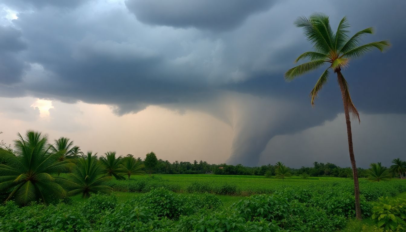
I’ll never forget the first time I saw a funnel cloud forming in the distance. My heart raced as I watched the sky turn an eerie shade of green, and the air grew thick with tension.
It was both exhilarating and terrifying, a stark reminder of just how small we are compared to the forces of nature.
Severe thunderstorms and tornadoes rank among the most dramatic and destructive weather events on our planet. These powerful storms unleash devastating forces, causing widespread damage and posing significant risks to life and property.
But what exactly causes these intense weather events, and how can we better understand and prepare for them?
The Science Behind Severe Thunderstorms
Severe thunderstorms form when specific atmospheric conditions align. The key ingredients include:
- Atmospheric instability
- Strong updrafts
- Moisture
- Wind shear
When warm, moist air near the ground rises rapidly and meets cooler air aloft, it creates the perfect conditions for thunderstorm development. As this unstable air continues to rise, it forms towering cumulonimbus clouds, often referred to as “thunderheads.”
The real magic happens when wind shear enters the equation. Wind shear occurs when winds change speed or direction with height, and it’s a crucial ingredient in the formation of supercell thunderstorms – the most powerful and long-lived type of thunderstorm.
These rotating storms are the primary producers of tornadoes, those violently rotating columns of air that extend from the storm to the ground.
The Anatomy of a Supercell
Supercell thunderstorms are complex structures with several distinct features:
- Updraft: The core of the storm, where warm, moist air rises rapidly.
- Downdraft: An area of sinking air, often accompanied by heavy precipitation.
- Mesocyclone: A rotating updraft that can lead to tornado formation.
- Wall cloud: A lowering of the cloud base beneath the mesocyclone.
- Anvil: The flat, spreading top of the cumulonimbus cloud.
Understanding these components helps meteorologists identify potentially dangerous storms and issue timely warnings.
The Birth of a Tornado
Tornadoes form within supercell thunderstorms when the rotation in the mesocyclone tightens and intensifies. As the rotating column of air descends from the cloud base, it can eventually make contact with the ground, becoming a fully-fledged tornado.
The exact mechanisms of tornado formation are still not fully understood, and ongoing research continues to shed light on this complex process. Factors such as the interaction between the updraft and downdraft, as well as temperature and moisture gradients within the storm, all play crucial roles.
Experiencing Nature’s Fury
Understanding the mechanics of these storms is one thing, but experiencing them firsthand is something else entirely. I remember standing on my front porch during a particularly intense thunderstorm, watching as lightning illuminated the sky in a dazzling display of nature’s power.
The air was charged with electricity, and I could feel the thunder reverberating through my chest.
It was a humbling reminder of the incredible forces at work in our atmosphere.
But severe thunderstorms and tornados aren’t just awe-inspiring – they’re also incredibly dangerous. That’s why it’s crucial to have a solid understanding of severe weather safety and preparedness.
Advanced Warning Systems
One of the most important tools in our arsenal for dealing with severe weather is the advanced warning systems we’ve developed over the years. Doppler radar has revolutionized our ability to detect and track severe storms.
These sophisticated systems can pick up on the telltale signs of rotation within a thunderstorm, giving meteorologists valuable time to issue warnings.
Doppler radar works by sending out pulses of electromagnetic waves and analyzing the reflected signals. By measuring the frequency shift of these returned signals, meteorologists can decide the speed and direction of precipitation within a storm.
This allows them to identify areas of rotation that could indicate the presence of a mesocyclone or developing tornado.
However, even with these advanced tools, predicting exactly where and when a tornado will touch down stays a significant challenge. Tornados can form and dissipate quickly, and their paths can be erratic and unpredictable.
The Role of Storm Chasers
Storm chasers play a crucial role in our understanding of severe storms by providing on-the-ground observations and data. These intrepid weather enthusiasts often put themselves in harm’s way to gather valuable information about storm structure, behavior, and intensity.
I’ve had the opportunity to tag along with a storm chasing team, and let me tell you, it’s an experience like no other. The adrenaline rush of getting up close and personal with a supercell is indescribable, but it’s also incredibly dangerous and should only be attempted by trained professionals.
Storm chasers use a variety of tools and techniques to track and observe severe weather, including:
- Mobile weather stations
- High-resolution cameras and video equipment
- GPS and mapping software
- Portable radar systems
The data collected by storm chasers helps improve our understanding of severe weather phenomena and can lead to more accurate forecasting and warning systems.
Staying Safe During Severe Weather
For those of us who aren’t storm chasers, the best way to stay safe during severe weather is to be prepared and informed. Having a well-stocked emergency kit and a solid plan in place can make all the difference when minutes count. I always make sure to have a NOAA Weather Radio on hand, as well as plenty of batteries, non-perishable food, and water.
Essential Items for Your Emergency Kit
- NOAA Weather Radio
- Flashlights and extra batteries
- First aid kit
- Non-perishable food and water (at least a 3-day supply)
- Manual can opener
- Prescription medications
- Important documents in a waterproof container
- Cash and credit cards
- Warm clothing and blankets
- Personal hygiene items
One of the most important things to remember during a severe thunderstorm or tornado warning is to seek suitable shelter immediately. If you’re at home, head to the lowest level of the building, preferably in an interior room without windows.
If you’re caught outside, find the nearest sturdy building or, as a last resort, lie flat in a low-lying area.
It’s also crucial to stay informed about the latest weather conditions and warnings. I personally rely on a combination of local news stations, weather apps, and social media to stay on top of developing situations.
Many communities also have outdoor warning sirens that sound when severe weather is imminent.
The Impact of Climate Change
While we’ve made significant strides in our understanding and prediction of severe thunderstorms and tornados, there’s still much to learn. Climate change is altering weather patterns across the globe, potentially leading to more frequent and intense severe weather events.
Some of the ways climate change may impact severe weather include:
- Increased atmospheric instability because of warmer temperatures
- Changes in jet stream patterns that could affect storm development
- Alterations in moisture distribution that could influence storm intensity
This makes ongoing research and education about these phenomena more important than ever. Scientists are working to develop more accurate climate models that can help predict how severe weather patterns may change in the coming decades.
Emerging Technologies in Severe Weather Research
As we continue to push the boundaries of our knowledge about severe storms, new technologies are emerging that could change our approach to weather prediction and safety. Some exciting developments include:
- Advanced computer modeling: Supercomputers are allowing for more detailed and accurate simulations of severe weather events.
- Drones for storm observation: Unmanned aerial vehicles can provide valuable data from within storms without putting human lives at risk.
- Artificial intelligence and machine learning: These technologies are being used to analyze vast amounts of weather data and improve forecasting accuracy.
- High-resolution satellite imagery: New satellites are providing more detailed and frequent observations of severe weather systems.
- Phased array radar: This next-generation radar technology promises faster and more precise storm detection.
These advancements are helping us better understand, forecast, and respond to severe weather events, potentially saving lives and reducing property damage.
Educating Yourself About Severe Weather
For those looking to deepen their understanding of severe thunderstorms and tornados, there are plenty of resources available. Local weather offices often offer storm spotter training courses, which can provide valuable insights into storm structure and safety.
These courses teach participants how to identify key features of severe storms and how to report their observations to meteorologists.
Online courses and webinars are also great options for those looking to expand their knowledge from the comfort of their own homes. Many universities and meteorological organizations offer free or low-cost educational materials on severe weather topics.
Some excellent resources for learning about severe weather include:
- The National Weather Service’s SKYWARN program
- The COMET Program’s MetEd website
- The American Meteorological Society’s education resources
- Local meteorology clubs and organizations
By educating yourself about severe weather, you increase your own safety and become a valuable asset to your community during dangerous weather events.
The Psychological Impact of Severe Weather
It’s important to thank that severe weather events can have significant psychological impacts on people and communities. The fear and anxiety associated with tornados and severe thunderstorms can be intense, especially for those who have experienced these events firsthand.
Some common psychological effects of severe weather include:
- Post-traumatic stress disorder (PTSD)
- Anxiety and depression
- Sleep disturbances
- Increased substance abuse
- Relationship strain
If you or someone you know is struggling with the emotional aftermath of a severe weather event, it’s important to seek professional help. Many communities offer counseling services and support groups for those affected by natural disasters.
Building resilient communities that can withstand and recover from severe weather events needs collaboration between government agencies, businesses, and person citizens.
Some key elements of community resilience include:
- Robust emergency response plans
- Well-maintained infrastructure
- Strong communication networks
- Community education and preparedness programs
- Support systems for vulnerable populations
By working together, we can create communities that are better equipped to handle the challenges posed by severe weather events.
The Future of Severe Weather Research and Preparedness
As our understanding of severe weather continues to grow, so too does our ability to protect ourselves and our communities from its impacts. Ongoing research into the physics of severe storms, coupled with advancements in technology and communication, promises to alter our approach to severe weather preparedness.
Some areas of focus for future research and development include:
- Improving long-term forecasting of severe weather outbreaks
- Developing more effective warning systems and communication strategies
- Creating stronger, more resilient building materials and construction techniques
- Enhancing our understanding of the impacts of climate change on severe weather patterns
- Exploring new methods for reducing the damage caused by severe storms and tornados
By continuing to invest in these areas, we can hope to reduce the loss of life and property associated with severe weather events in the years to come.
People Also Asked
What causes a tornado to form?
Tornados typically form within supercell thunderstorms when strong rotation develops in the storm’s updraft. This rotation is often caused by wind shear, which occurs when winds change speed or direction with height. As the rotation intensifies and extends from the cloud base to the ground, a tornado is born.
How long does a tornado usually last?
The lifespan of a tornado can vary greatly, but most tornados last between a few seconds to several minutes. Some rare, long-track tornados can continue for over an hour, but these are exceptional cases.
What’s the difference between a tornado watch and a tornado warning?
A tornado watch means that conditions are favorable for tornado development in the watch area. A tornado warning is issued when a tornado has been spotted or indicated by weather radar.
During a warning, immediate action should be taken to seek shelter.
Can tornados occur at night?
Yes, tornados can occur at any time of day or night. Nighttime tornados are particularly dangerous because they’re harder to see and people may be asleep when warnings are issued.
What’s the safest place to be during a tornado?
The safest place during a tornado is in a basement or storm cellar. If that’s not available, go to the lowest floor of a sturdy building and take shelter in an interior room away from windows, such as a hallway or bathroom.
How fast do tornado winds blow?
Tornado wind speeds can vary greatly. The weakest tornados have wind speeds less than 110 mph, while the strongest can exceed 300 mph. The average tornado has wind speeds between 110-165 mph.
Can tornados cross water?
Yes, tornados can cross bodies of water. When they do, they’re often called waterspouts.
However, tornados typically weaken when they move over water because of the loss of their warm, moist air source.
How do meteorologists detect tornados?
Meteorologists primarily use Doppler radar to detect tornados. This technology can identify areas of rotation within storms that may indicate tornado formation.
Ground observations from storm spotters and the public also play a crucial role in tornado detection.
What’s the largest tornado ever recorded?
The largest tornado on record was the El Reno, Oklahoma tornado of May 31, 2013. At its peak, it reached a width of 2.6 miles.
However, a tornado’s size doesn’t necessarily correlate with its intensity or destructive potential.
How do you prepare for tornado season?
Preparing for tornado season involves creating an emergency plan, assembling a disaster kit, identifying safe shelter locations, staying informed about weather conditions, and participating in tornado drills. It’s also important to secure outdoor objects that could become projectiles in high winds.
Key Takeaways:
- Severe thunderstorms and tornados are complex atmospheric phenomena driven by instability and wind shear.
- Advanced warning systems like Doppler radar have greatly improved our ability to detect and track severe storms.
- Personal preparedness, including having an emergency kit and plan, is crucial for staying safe during severe weather events.
- Ongoing research and education are essential as we face the potential for more frequent and intense severe weather because of climate change.
- Respect for the power of nature and a commitment to ongoing learning are key to navigating the challenges posed by severe thunderstorms and tornados.